By this time, you should have your basic GSSHA model working. I know you have put a lot of efforts to have your first GSSHA model and hopefully you feel confident in the results you are receiving when running it. If you are still having troubles with a basic GSSHA model talk to me about it immediately.
In this assignment, we will be start from this basic model and will experiment with different infiltration methods as we did in HMS.
Parameters
You will analyze various infiltration parameters in this exercise and it is important for you to understand how each of those parameters is determined and what watershed properties can be used to "index" these parameters.
1. No infiltration: This is our control case from which we will be able to compare other models. In this analysis, you will not consider any infiltration parameters. The overland flow surface roughness (necessary for runoff calculation) is characterized by Manning's coefficient. You can get the information about Manning's n from the following links. ( Link1 Link 2)
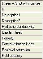
2. Infiltration considered: Here you will incorporate both infiltration as well as roughness characteristics. GSSHA's principal loss method is the physics based infiltration model Green and Ampt. The parameters for Green and Ampt are: Hydraulic conductivity (Ks), Capillary Head (ψf) Porosity (θs) and Field Capacity as well as two more parameters which are Pore Distribution Index (λ) and Residual Saturation (θr). The GSSHAwiki discusses how to estimate these parameters. The table found on the GSSHAwiki was developed by Rawls and Brakensiek.
Model Setup
Start with the base model of Judy's Branch you created in Assignment #15.
-
Have no digital dams, or if it does it should be in a stream
-
Have a Uniform index map and mapping table set up
-
Have streams with properly distributed vertices and smoothed channel bottom.
-
Have no major ponding problems in the surface runoff
-
Be executing properly
Assignment
-
Uniform Index map and uniform roughness
-
No infiltration
The index map being uniform, you will have only one land use defined in your watershed and thus you will have single roughness value. This is basically just running your base GSSHA model. We are performing this analysis so as to match the case with HMS analysis.
-
Precipitation: 2.5 inches, Type II temporal distribution
-
Manning's roughness: Use a uniform roughness value of 0.03
-
Run GSSHA to determine the runoff when no infiltration is considered.
-
-
Green and Ampt Method
The input parameters are basically the same as HMS but the algorithm in GSSHA also has a mechanism to redistribute the initial soil moisture when there is no rainfall and this maintains the continuity in the soil moisture when the next rainfall event occurs. (You can read about this method on the GSSHAwiki.) You have already experienced the methods of determining Green and Ampt parameters from the land use and soil information for HMS. We will use similar parameters here, but you can see, the index map is uniform representing same land use and soil type all over the watershed, so you will have single roughness parameter and a single set of infiltration parameters, making this model similar to what was run in HMS.

We will use the GA method for this case and perform some sensitivity analysis with the GA parameters. In GSSHA | Job control, you can choose the infiltration method to be Green and Ampt with soil moisture redistribution. In the figures to your right (seen from the Mapping Tables dialog), you can see the parameters for GA method. Besides these parameters you will also need to define the initial moisture, done separately from the GA parameters in the mapping table setup.
-
Precipitation: 2.5 inches, Type II temporal distribution
-
Manning's roughness: Use a uniform roughness value of 0.03
-
Infiltration parameters: Determine based on the uniform index map (select GSSHA | Mapping table, and switch to Infiltration tab, Generate ID's). We want to use a uniform set of values so we can compare more closely with the results of HMS. Use the table on the GSSHAwiki. Enter 0.1 for all soils for field capacity for this assignment.
-
In the GSSHA Job Control under Output Control turn on the output of the Cumulative Infiltration Depth, Infiltration Rate, and Soil Moisture. These results can help you get an idea of what is happening to rainfall lost to infiltration.
-
Initial Moisture: In the mapping table input you define initial soil moisture separately. If the soil is saturated this will equal the porosity. Use a value that approximates what you used for HMS.
-
Run GSSHA so that you capture the hydrograph properly.
-
Rerun GSSHA by increasing and decreasing the values of K by 25%
-
Rerun GSSHA by increasing and decreasing the values of Porosity by 25%
-
Rerun GSSHA by increasing and decreasing the values of Capillary head by 25%
-
Rerun GSSHA with initial moisture = porosity, and with initial moisture = 0.
-
-
2. Spatially defined soils using a non-uniform Index map
For this case, you will create a new index map from the SSURGO soils data (converted to a WMS Coverage). In the previous case (case 1), you had simplified the watershed properties by using a uniform index map (which matched the HMS model better). Here you will have multiple soils to define the GA parameters in the mapping tables.
Under GSSHA | mapping table, select the Infiltration tab, Generate ID's and enter suitable GA parameters for the different soil properties. Generally, the roughness parameters are derived from land use data and the infiltration parameters from soil data, but it is possible that some parameters are a function of both even though we are simplifying this to just use the soils.
-
Green and Ampt
Precipitation: 2.5 inches, Type II temporal distribution
Manning's roughness: Use a uniform roughness value of 0.03
Infiltration parameters: Determine based on the SSURGO soils data (select GSSHA | Mapping table, and switch to Infiltration tab, Generate ID's) and use the previously mentioned references.
Run GSSHA so that you capture the hydrograph properly.

3. Spatial variations in land use
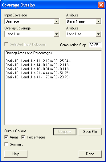
Here, we will see how the land use pattern affects the infiltration through the watershed. Using the coverage overlay calculator in WMS, you can determine the percentage of watershed area covered by different land use and soil types (In the figure to the right, you can see how WMS calculates percentage area for different land uses)
According to the USGS land use classifications LUCODE attributes with values between 10-19 are urban areas. For this part of assignment, calculate coverage overlay for your watershed and see which portion of land (and what percentage) are urban areas. If an urban area is "directly connected" there is no infiltration (this is the inherent assumption in models like HMS), but if it is not then it runs off onto land uses that are pervious (something GSSHA can handle). Now, we will see how this consideration affects the hydrograph.
a. Comparison of land use changes in HMS and GSSHA
i) Go back to your Green and Ampt HMS project and in percent impervious area field, enter the percentage of urban land use as impervious . Adjust your Green and Ampt parameters if you feel it is necessary. Then run HMS, we will use the results to compare with GSSHA.
ii) For GSSHA we want the soil parameters to be the same as HMS everywhere (one index value) except the urban areas. The easiest way to do this is to use the Land Use map you downloaded to define the infiltration parameters. For ID's that are not urban use the values you determined for part 1 that most closely match HMS, then for the IDS that are urban make the hydraulic conductivity = 0 and the capillary head = 0 (impervious). Save your project and run GSSHA with all other parameters the same. Keep the roughness uniform with a value of 0.03.
Compare how HMS and GSSHA treat imperviousness .
To turn in with modeling exercises:
-
Hydrographs from all of the above scenarios. Download the template found here and copy and paste in your outflow hydrograph values from WMS into the appropriate columns. The graphs should already be set up, but feel free to include any other graph of interesting comparisons you think of.
To turn in with losses review assignment (but at least think about it now):
-
Compare no infiltration with infiltration as defined in part 1.
-
Compare uniform infiltration with spatial distribution of infiltration parameters.
-
Analyze the sensitivity of the different GAR parameters form 2b.
-
Compare GA method in HMS with GAR method in 1 and 2. Try to compare based on the relevancy with HMS modeling.
-
Compare how HMS and GSSHA treat impervious areas.
-
Any other important aspects/scenario that you might have observed.
*****